|
1940: Foster Ave (Rugby - Marlborough Roads) |
 |
| 1940: Foster Ave (Rugby - Marlborough Roads) |
 |
| 1940: Foster Ave (Argyle - Rugby Roads) |
 |
| 1940: Avenue H (Brighton Line - E 15th St) |
 |
| 1940: Avenue H (Brighton Line - E 15th St) |
 |
| 1940: Avenue H (Brighton Line - E 15th St) |
 |
| 1940: Avenue H (Corner of E 14th St) |
 |
| 1940: Avenue H (NE Corner of E 12th St) |
 |
| 1940: Avenue H (SW Corner of E 15th St) |
 |
| 1940: Hotel Oak (SW Corner, Ave H & E 12th St) |
 |
| 1940: Avenue H (North Side, At Brighton Cut) |
 |
| 1940: Coney Island Ave South from Ave H (Kent Theater in Distance) |
 |
| 1940: Newkirk Ave, SE Corner at Rugby Road |
 |
| 1940: Newkirk Ave, SW Corner at Marlborough Rd |
 |
| 1940: Newkirk Ave, North Side, Rugby-Marlborough Rd |
 |
| 1940: Newkirk Ave, SW Corner of E. 16th St |
 |
| 1940: Glenwood Rd at Coney Island Ave |
 |
| 1940: Foster Ave at Coney Island Ave |
Le Plus Ce Change: 1940 vs 1983 vs 2018
In October the City made available ONLINE its collection of 1940s "tax photos" -- photographs taken in support of its real property tax assessments. Unlike the previously posted 1980s photos, these are all black & white. They are also of much better quality.
So, as we bid a fond adieu to 2018, I thought we'd take a look at the buildings and places in our neck of the woods that have changed the most over the past 79 years.
Our first stop is the southeast corner of Glenwood & Westminster Roads. Back in 1904, when Lott's Woods were leveled by the Germania Real Estate & Improvement Company, a civil engineer named Fred G. Dennington was hired to draw up a map of the area. Accordingly on December 30th of that year he submitted what would be filed as Map 1457 and thereafter referenced in many subsequent deeds as "Map of Part 3 of South Midwood."
In 1905 John Corbin erected a beautiful colonial revival home that occupied three lots on Dennington's map (numbers 918, 919 and 920) which measured in total 100 feet along Westminster and 60 feet along Glenwood Road. In the 1940 photo below, there is a garage that was added circa 1920 on the southern end of the property.
During the 1960s, a period of floundering property values, suburban flight and red-lining of much of Flatbush by lending institutions, the home was unoccupied following the death of Isador Krasnor.
His niece, Pearl Preiss, who owned 1304 Glenwood Road, sold the house in an estate sale in January 1969 to realty speculators from Valley Stream who demolished the home and laid the foundation for three new homes, then sold the properties in 1972 to new owners who completed the construction: a rectangular brick box containing three two-family brick homes, three stories high. The lots were irregular as depicted in the tax map and were given three street addresses: 1202 Glenwood, 705 & 707 Westminster Road.
 |
1972 Sep 10: Ad in the NY Daily News for the Three Original Plots
per the 1904 Map Following the Demolition of the Corbin House in 1970 |
 |
Tax Lots Since 1970 (from North to South):
1202 Glenwood Rd,
705 Westminster Rd, 707 Westminster Road |
The photos below impress me as a prima facie argument for landmarking West Midwood, along with Ditmas Park West and the rest of Victorian Flatbush.
 |
| 1940: 1202 Glenwood Road |
 |
| 1980: 1202 Glenwood Road |
 |
| 2018: 1202 Glenwood Road |
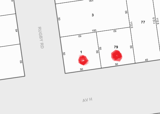
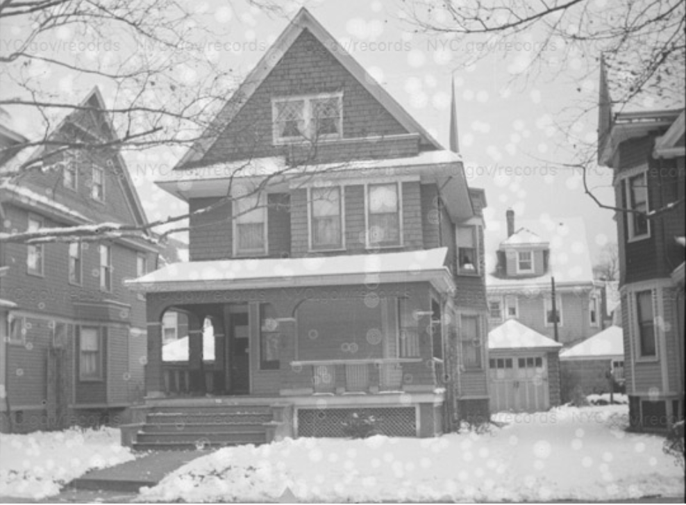
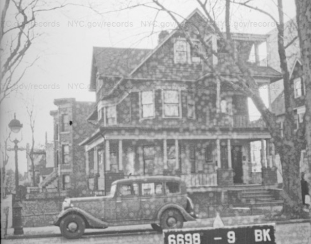
Moving on, let's consider another magnificent corner building that was demolished and replaced by two modern brick structures at the northeast corner of Rugby Road and Avenue H: 1403 and 1407 Avenue H. In this instance, when owners failed to pay property taxes over an extended period of time, the City took possession in May 1966 of the magnificent Corbin-built home. In the ensuing auction in November 1966, developers won the bid at a cost of $18,600 and demolished the 61 year-old house. They broke the property up into two lots of equal size and built two detached brick houses.
 |
1940: 1403 Avenue H
|
 |
| 1966: One Lot Split Into Two |
 |
1967 Nov 4 NY Daily
News
|
 |
| 1980s |
 |
| 2018 |
Aside from these demolitions, West Midwood’s original homes have remained intact. Fires have damaged some homes but they were all rebuilt with the same footprint, retaining the Queen Anne/ Colonial Revival style.
There was one additional demolition, however, that did not involve a residence: it was the Glenwood Road footbridge over the Brighton line.
The bridge was erected in late 1908, more than a year after the Brighton trench was excavated as part of the grand project mandated by the NY State Grade Crossing Commission: to eliminate the many barriers to the free-flow of traffic, whether it be trains, trollies, motor vehicles, horses or pedestrians. The construction company that finished the project was delayed by another one of their Brooklyn projects: building the Brooklyn Academy of Music.
 |
1908 Aug 25: Brooklyn Eagle
Note The Typo. Tsk tsk tsk. |
 |
1911: Glenwood Rd East
from Rugby Rd Showing
the Grand Brick Staircase |
 |
| PS 35, Glenwood & E 23rd St |
The bridge connected West Midwood to Midwood Park and allowed school children quicker access to PS 35 at East 23rd Street seven blocks due east and later, Midwood High School on Bedford Avenue.
 |
1940: Note
brick staircase (far left)
at foot of Glenwood Rd in West Midwood
|
 |
1940: Shot from Footbridge
(Note Bannister Lower Left)
on Midwod Park Side
Looking at Finkel Home |
 |
| 1980s: Stairway Gone |
But alas the lawlessness that erupted in the early ‘70s included miscreants throwing objects from the bridge onto passing trains and youths congregating on and about the bridge to no doubt debate the great ideas of their time. As a result, the footbridges at Albemarle Road and Glenwood Road would be dismantled. But the wheels of government grind slowly and the dismantlement would occur in stages. First, the brick staircases were leveled, and wire fences erected to prevent access to the spans. Then, in the mid-1980s, the span structures themselves were removed. Finally, circa 1990, the concrete underpinnings at street level were drilled away.
 |
1980s: Glenwood Road Footbridge
|
 |
| 2018: Glenwood Road Minus Bridge |
Some things have changed very little over the past seven decades. For instance, the Key Food on Foster Avenue was formerly Contor Food Center in the 1980s and before that, a Bohack from the 1940s to the 1960s.
 |
1940: 1409 Foster
Avenue
|
 |
| 1980s: 1409 Foster Avenue |
 |
2000s: 1409 Foster Avenue (Key Food)
|
By the same token Chase Bank was formerly Manufacturers Hanover
Bank in the 1980s and before that, the Brooklyn Trust Company.
 |
1940: 1509 Foster
Avenue
|
 |
1980s: 1509 Foster
Avenue (the New Bank Expanded Its Footprint, Demolishing the Adjoining Building)
|
 |
2018: 1509 Foster
Avenue
|
The Sunset Bagels & Café opened just two years ago next door to the Chase Bank. In 1940 it was Leahy's Café.
 |
| 1940:
Leahy's Café |
 |
| 2018:
Sunset Bagels & Café |
Surprising
Factoids!
There was once a 100 seat cinema at Newkirk Avenue & East 16th
Street that showed Hollywood movies as late as 1940. This movie house had an
interesting history. Its entrance when it opened in 1910 was originally where
the C-Town Supermarket is today, at 597 East 16th Street. In 1928 a marquee
 |
| 1914 Post Card. Note Wall on Left |
 |
| 1914 Post Card |
was erected, visible in the shot below looking north on
East 16th Street toward Newkirk, and the name was changed from
T.N.F. (after its founders, Benjamin Tittle and Henry F. Newberry) to simply The
Newkirk. It was one of the first motion picture theaters on the East Coast equipped
for the showing of talking pictures.
 |
| 1930 |
Sometime in the 1930s, the entrance and marquee on East 16th
Street were abandoned. Now patrons entered from 1604 Newkirk Avenue. The
Newkirk briefly became a “legitimate theater” in 1935-1936, serving as the
Newkirk Art Theatre for a repertory group, the Mansfield Stock Company, before
returning to films.
 |
| 1928 Nov 24 Eagle Ad |
 |
| 1936 Jan 2 NY Daily News |
 |
| 1935 Dec 17 NY Daily News |
 |
| 1935 Dec 1 Brooklyn Eagle |
 |
1940: Newkirk South
Side, Just East of E. 16th St.
Note: “Intimate” Meant
Small, Not Sexy!
|
 |
1980s (Tenants Council & Avril's Replace Theater)
|
 |
2011 ("French Cleaners" Survives!)
|
 |
2018 (New Facades but French Cleaners Lives On)
|
The most noteworthy news clip for this theater concerned a near
disaster in November 1937 when two Brooklyn Tech chemistry students attended a
showing one weeknight but forgot to leave their chemicals at home, resulting in
an explosion of a test tube amidst a full house watching “Captain Calamity.”
 |
| 1937 Dec 29 Brooklyn Eagle |
 |
| 1937 March 25: Movie Listings, Brooklyn Eagle |
The corner wall at Newkirk and E. 16th Street, two doors down from
the "intimate playhouse" survived into our decade, prettified by a
mural. A more artsy mural survives still.
 |
1940: Note Cinema Far
Left & the Wall
That Survived into
This Decade
|
 |
2011: Same Wall That
Once Abutted The "T N F" on
E 16th St
Abuts C-Town Above
 |
| 2013: Fancy Schmancy Mural |
|
But this “intimate playhouse” eventually fell victim to competition
provided by two less “intimate” theaters on Coney Island Avenue: the Kent,
south of Avenue H, still going strong, and the Leader, north of Newkirk, now the site of Atlas Steak House. Both were owned by the same
entrepreneur who developed ingenious gimmicks to maintain attendance during the
dawning of the age of television. But that’s a tale for another day.
Marlborough Court in the 1940s
Waldorf Court in the 1940s
Wellington Court in the 1940s
Dekoven Court in the 1940s
Rugby Road in the 1940s
Glenwood Road in the 1940s
Argyle Road in the 1940s
Westminster Road in the 1940s
Avenue H in the 1940s